In Openstreetmap US, California Fresno area, a controversial [0] series of imports of legal property records (aka PARCEL) are mixed in with other POLYGONS. Many various POLYGON in Fresno now share the tag landuse=residential, both the PARCEL legal records and real building footprint POLYGON, as well as various others. After reviewing the wiki talk page, relevant discussions, and discussing online briefly, this post looks at the OSM context; estimates the extent of these imports by examining similar, nearby areas; compares the OSM records to actual current PARCEL records; proposes a deletion criteria and finally, examines the extent of the proposed deletion.
[0] changeset/26356220 * changeset/26357831
OSM Wiki on Parcels -LINK- -TALK-
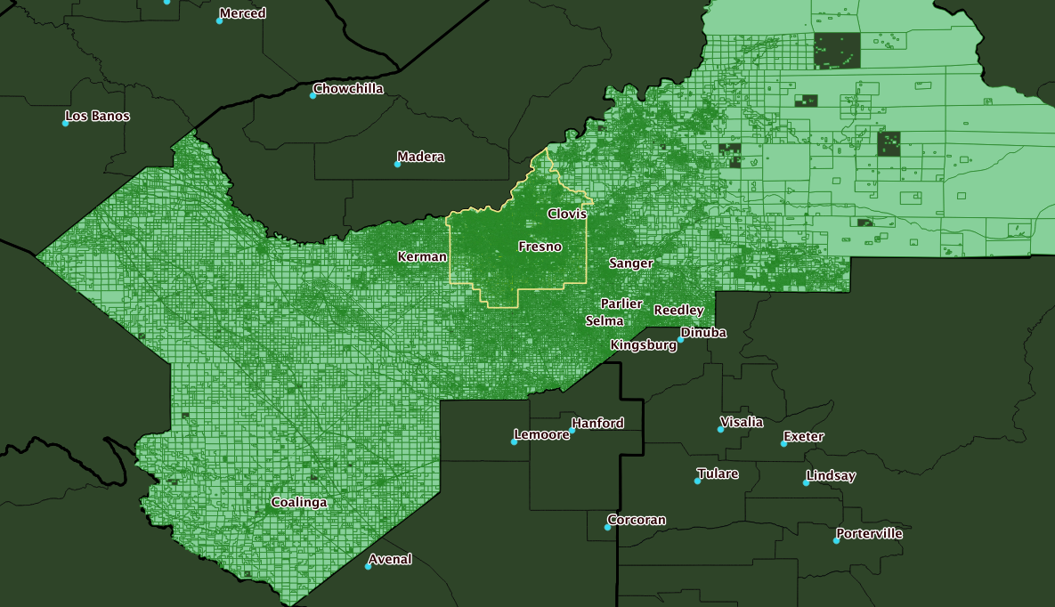
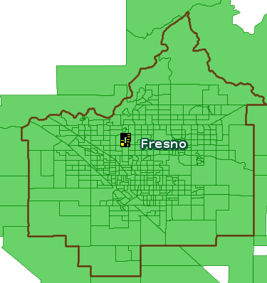
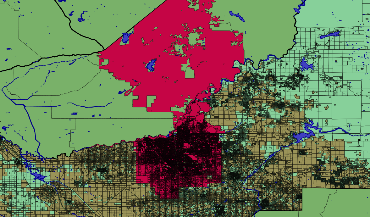
Context: Fresno County is big — but the real-world residential areas are confined almost entirely to the City of Fresno.
Q. What tag 'landuse' values are present in County Subdivision Fresno?

 151670 | residential
   6644 | commercial
   6463 | NULL
   3859 | industrial
    706 | farm
    574 | vineyard
    498 | orchard
    453 | meadow
    109 | garages

less than 100:
  basin,farmyard,recreation_ground,grass,farmland,religious,cemetery,retail,
  quarry,reservoir,railway,landfill,construction,institutional
Next, expand the query to the entire five-county region
Q. What tag 'landuse' values are present in the five county area
-- Kings, Madera, Tulare, Kern, Fresno

 207902 | NULL
 203000 | residential
  11697 | commercial
   7054 | farm
   6679 | orchard
   5941 | industrial
   5251 | vineyard
   5029 | meadow
   2475 | farmland
   1980 | farmyard
    885 | grass

less than 300:
   garages,cemetery,recreation_ground,basin,quarry,reservoir,religious,retail
  forest,scrub,military,landfill,railway,pond,greenhouse_horticulture,construction
So, 150,000 of the 200,000 landuse=residential tagged POLYGONs in a five-county area, are in just the Fresno City CCD.
Attribution On inspection, a large number of likely PARCEL records in Fresno, carry an attribution tag with one of several recognizable values: Caltrans (4), FMMP (3) and Fresno_County_GIS.
example data:
 "type"=>"multipolygon", "landuse"=>"vineyard", "attribution"=>"Fresno_County_GIS"
 "crop"=>"field_cropland", "type"=>"multipolygon", "landuse"=>"farm", "attribution"=>"Fresno_County_GIS"
 "crop"=>"field_cropland", "type"=>"multipolygon", "landuse"=>"farm", "attribution"=>"Fresno_County_GIS"
 "crop"=>"native_pasture", "type"=>"multipolygon", "landuse"=>"meadow", "attribution"=>"Fresno_County_GIS"
 "crop"=>"native_pasture", "type"=>"multipolygon", "landuse"=>"meadow", "attribution"=>"Fresno_County_GIS"
 "type"=>"multipolygon", "landuse"=>"vineyard", "attribution"=>"Fresno_County_GIS"
 "crop"=>"field_cropland", "type"=>"multipolygon", "landuse"=>"farm", "attribution"=>"Fresno_County_GIS"
 "type"=>"multipolygon", "landuse"=>"vineyard", "attribution"=>"Fresno_County_GIS"
 "crop"=>"field_cropland", "type"=>"multipolygon", "landuse"=>"farm", "attribution"=>"Fresno_County_GIS"
 "type"=>"multipolygon", "trees"=>"orange_trees", "landuse"=>"orchard", "attribution"=>"Fresno_County_GIS"
 "type"=>"multipolygon", "landuse"=>"residential", "lot_type"=>"single family residential properties", "other_use"=>"S", "attribution"=>"Fresno_County_GIS", "primary_use"=>"000", "secondary_use"=>"VLM"
 "type"=>"multipolygon", "wood"=>"mixed", "landuse"=>"farm", "natural"=>"wood", "attribution"=>"Fresno_County_GIS"
 "type"=>"multipolygon", "landuse"=>"vineyard", "attribution"=>"Fresno_County_GIS"
 "type"=>"multipolygon", "landuse"=>"orchard", "attribution"=>"Fresno_County_GIS"
Detailed counts in Fresno County and the Fresno CCD
-- Fresno County:  geoid  06019 / tl_2016_us_county
241860 - all multipolygons
231624 - tag landuse
196017 - tag landuse = 'residential'
230685 - tag 'attribution'
230612 - tag 'attribution' ~* 'GIS'
----------------------------------------------------
-- Fresno CCD:   geoid   0601991080
171200 - all multipolygons
164737 - tag landuse
151670 - tag landuse = 'residential'
166163 - tag 'attribution'
166147 - tag 'attribution' ~* 'GIS'
----------------------------------------------------
-- Fresno County outside of Fresno CCD (derived)
 70660 - all multipolygons   (241860 - 171200)
 66887 - tag landuse         (231624 - 164737)
 44347 - tag landuse = 'residential'  (196017 - 151670)
 64465 - tag 'attribution' ~* 'GIS'   (230612 - 166147)
Qry - count the occurances of attribution 'GIS'   AND
  landuse = 'residential'; area Fresno County, by cousub
           name           | count
--------------------------+--------
 Caruthers-Raisin City    |   1400
 Fresno                   | 150681
 Kerman                   |   4093
 Reedley                  |   5967
 Mendota                  |   1779
 San Joaquin-Tranquillity |   1030
 Coalinga                 |   2528
 Firebaugh                |   1152
 Orange Cove              |   1579
 Kingsburg                |   3557
 Huron                    |     87
 Fowler                   |   1527
 Sierra                   |    963
 Parlier-Del Rey          |   2633
 Sanger                   |   7796
 Riverdale                |   1208
 Laton                    |    599
 Selma                    |   6221
Compare current parcel data (670 records) to OSM multipolygon with tag landuse=residential (350 records), in a sample Fresno blockgroup ('060190045051')
BBOX="-119.7994,36.8084,-119.7903,36.8229"


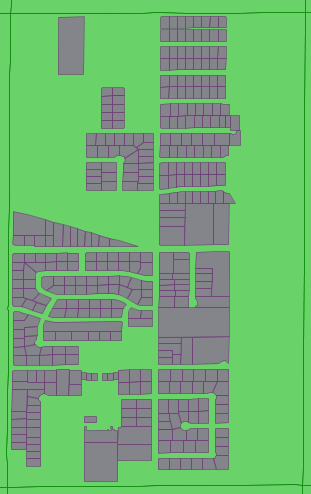
This looks promising: take all OSM multipolygons marked landuse=residential, then remove WHERE tag attribution exists AND tag building does not exist …

Some Links:
https://help.github.com/articles/mapping-geojson-files-on-github/
-- County of Fresno, subdivision Fresno geoid = '0601991080'
--  multipolygons m is a raw dot-pbf import of OSM

-- Qry - Show all landuse tags and a count of occurances
--   area: Fresno CCD
--
select count(*), all_tags -> 'landuse'
FROM multipolygons m,  tl_2016_06_cousub cs
WHERE
    cs.geoid = '0601991080'  AND
    st_intersects( m.wkb_geometry, cs.geom)
GROUP BY all_tags -> 'landuse'
ORDER BY  all_tags -> 'landuse';

/* count |   landuse tag
--------+-------------------
     48 | basin
     11 | cemetery
   6644 | commercial
      1 | construction
    706 | farm
     24 | farmland
     43 | farmyard
    109 | garages
     28 | grass
   3859 | industrial
      1 | institutional
      1 | landfill
    453 | meadow
    498 | orchard
      2 | quarry
      1 | railway
     37 | recreation_ground
     19 | religious
      2 | reservoir
 151670 | residential
      6 | retail
    574 | vineyard
   6463 |
*/

--=====================================================
--
--  Kern County - FIPS 029
--  Fresno County - FIPS 019
--

-- Qry - Show CCDs and a count of tag landuse = 'residential'
--   area: Fresno County, Kern County
--
select count(*), (cs.geoid, cs.name, cs.countyfp)
FROM multipolygons m, tl_2016_06_cousub cs
WHERE
    cs.countyfp IN ( '019', '029' )  AND
    all_tags -> 'landuse' = 'residential'  AND
    st_intersects( m.wkb_geometry, cs.geom)
GROUP BY  (cs.geoid, cs.name, cs.countyfp)
ORDER BY   (cs.geoid, cs.name, cs.countyfp) ;

/*
   1408 | (0601990390,"Caruthers-Raisin City",019)
   2558 | (0601990530,Coalinga,019)
   1170 | (0601991000,Firebaugh,019)
   1541 | (0601991060,Fowler,019)
 151670 | (0601991080,Fresno,019)
           ...............
     60 | (0602990130,Arvin-Lamont,029)
    724 | (0602990180,Bakersfield,029)
          ................
   1096 | (0602993320,Tehachapi,029)
    188 | (0602993570,Wasco,029)
    715 | (0602993635,"West Kern",029)
*/

--==================================================
--
-- Qry - Show all landuse tags and a count of occurances
--   area: Fresno County, Kern County
----
select count(*), all_tags -> 'landuse'
FROM multipolygons m, tl_2016_06_cousub cs
WHERE
    cs.countyfp IN ( '019', '029' )  AND
    st_intersects( m.wkb_geometry, cs.geom)
GROUP BY all_tags -> 'landuse'
ORDER BY  all_tags -> 'landuse';

/* count |  landuse tag
--------+-------------------------
      1 | aerodrome
     83 | basin
     54 | cemetery
  11107 | commercial
      1 | conservation
      1 | construction
   5160 | farm
   2426 | farmland
   1034 | farmyard
      5 | forest
    268 | garages
    885 | grass
      1 | greenhouse_horticulture
   5830 | industrial
      1 | institutional
      3 | landfill
   3318 | meadow
      4 | military
   6519 | orchard
     45 | quarry
      3 | railway
     86 | recreation_ground
     19 | religious
     19 | reservoir
 201341 | residential
     13 | retail
     16 | scrub
   5225 | vineyard
 203195 |
*/

--===================================================
--
-- Qry - Show all landuse tags and a count of occurances
--   area: Bakersfield city, Kern County (similar to Fresno city )
--

select count(*), all_tags -> 'landuse'
FROM multipolygons m, tl_2016_06_place p
WHERE
    p.namelsad = 'Bakersfield city'  AND
    st_intersects( m.wkb_geometry, p.geom)
GROUP BY all_tags -> 'landuse'
ORDER BY  all_tags -> 'landuse';

/* count |   landuse tag
--------+-------------------
      4 | cemetery
    687 | commercial
     78 | farm
      3 | farmland
     23 | farmyard
    836 | grass
    261 | industrial
     52 | meadow
     18 | orchard
      1 | railway
      8 | recreation_ground
    710 | residential
     16 | scrub
 119669 |
*/

--===================================================
--
-- Qry - Show all landuse tags and a count of occurances
--   area: Fresno City
--
--
select count(*), all_tags -> 'landuse'
FROM multipolygons m, tl_2016_06_place p
WHERE
    p.namelsad = 'Fresno city'  AND
    st_intersects( m.wkb_geometry, p.geom)
GROUP BY all_tags -> 'landuse'
ORDER BY  all_tags -> 'landuse';

/* count |   landuse tag
--------+-------------------
     25 | basin
      5 | cemetery
   5523 | commercial
      1 | construction
     67 | farm
      4 | farmland
      4 | farmyard
     65 | garages
     12 | grass
   2410 | industrial
      1 | landfill
    268 | meadow
     45 | orchard
      1 | railway
     26 | recreation_ground
     19 | religious
      1 | reservoir
 105930 | residential
      5 | retail
     15 | vineyard
   5192 |
*/