Brian M Hamlin
GeoCal-ish
OSGeo Charter Member, California Chapter
EMail :   maplabs at light42 dot com
Senior Editor, committer OSGeoLive Linux

OSGeo dot org GNU/Linux on LXQt Ubuntu Distro-Watch https://distrowatch.com/table.php?distribution=osgeo
OSGeo gitea | github | TRAC | launchpad
Public Speaking and Technical Presentation Credits (selected):

Analysis Ready Data #ARD23 2023, Pipeline Session [LINK]
FOSS4G Boston 2017 Seminar on OSGeoLive Linux
Harvard Center for Geographic Analysis [LINK]
Taught a two hour seminar: intro to desktop Linux and QGIS; overview of the Openstreetmap project;
overview of internationalization (i18n) on OSGeoLive; overview of Openstreetmap edit tools; tour of PostGIS
Conference Keynote presentation on #osgeolive (5 minutes) ~1000 persons audience including representatives of the major schools of Boston
Berkeley Institute for Data Science BIDS
Graduate Science Faire Presentations 2017 [LINK] and Spring 2018
complete pipeline for RGBI ortho-imagery, custom segmentation kernel; prep for Object-based Image Analysis (OBIA);
Machine Learning OBIA search for classified polygons implemented in python and PostGIS.
UCBerkeley Rausser College / brown bag seminar; presented a one hour lecture on two occasions – GDAL + QGIS
Debian Server Admin:
Assembled and installed Photoprism server — a personal photo management CMS powered by Go and Google TensorFlow; assembled and installed Tensorflow binary library. Photoprism implements text to photo searching and image classification using a pre-trained AI model, NASNet Mobile 224. Ingest and index 60,000 photos from multiple sources.
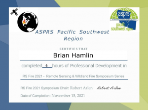
ASPRS 2021 RS_Fire Series Continuing Education Credits
OSGeoLive Jupyter Notebooks | OSGeo Advocate Profile | USGS Open House 2009 | Calif OSGeo hack-a-thon
https://openprofile.dev/profile/maplabs
BCE • Berkeley Common Scientific Compute Environment for Research and Education
UC Berkeley paper published: SciPy 2014


